Gor Maps
"I shrugged. Much of Gor was terra incognita. Few knew well the lands on the east of the Voltai and Thentis ranges, for example, or what lay west of the farther islands, near Cos and Tyros. It was more irritating, of course, to realize that even considerable areas of territory above Schendi, south of the Vosk, and west of Ar, were unknown."
-- Explorers of Gor, pg 16
"Ax Glacier was far to the north, a glacier spilling between two mountains of stone, taking in its path to the sea, spreading, the form of an ax. The men of the country of Ax Glacier fish for whales and hunt snow sleen. They cannot farm that far to the north. Thorgeir, it so happened, of course, was the only man of the Ax Glacier country, which is usually taken as the northern border of Torvaldsland, before the ice belts of Gor's arctic north, who was at the Thing-Fair."
-- Marauders of Gor, pg 139
"I could see the blue line of the Hrimgar Mountains in the distance to the south. To the north the tundra stretched forth to the horizon. Many people do not understand the nature of the polar north. For one thing, it is very dry. Less snow falls there generally than falls in most lower latitudes. Snow that does fall, of course, is less likely to melt. Most of the land is tundra, a cool, generally level or slightly wavy, treeless plain. In the summer this tundra, covered with mosses, shrubs and lichens, because of the melted surface ice and the permafrost beneath, preventing complete drainage, is soft and spongy. In the winter, of course, and in the early spring and late fall, desolate, bleak and frozen, wind-swept, it presents the aspect of a barren, alien landscape."
-- Beasts of Gor, pg 195-196
"It is not known how far these forests extend. It is not impossible that they belt the land surfaces of the planet. They begin near the shores of Thassa, the Sea, in the west. How far they extend to the east is not known. They do extend beyond the most northern ridges of the Thentis Mountains."
-- Captive of Gor, pg 129
"The Laurius is a winding, long, gentle, slow river. It does not have the breadth and current which are the terrors of the titanic Vosk farther to the south, well below Ko-ro-ba, though well above Ar, which is said to be the greatest city of all known Gor. The Laurius, like the Vosk, flows in a generally westernly direction, though the Laurius inclines more to the southwest then the great Vosk."
-- Captive of Gor, pg 59-60
"We had taken the Tesephone from the wharves of Laura, and ascended the river some twenty pasangs. It was there, on the north bank, that we made our camp. Above Laura the river is less navigable than below, particularly in the late summer"
-- Hunters of Gor, pg 85
"The Vosk is a mighty river which flows westward, emptying into a vast rence delta, finding its way eventually to Thassa, the sea."
-- Slave Girl of Gor, pg 248
"On river barges, for hundreds of pasangs, I had made my way down the Vosk, but where the mighty Vosk began to break apart and spread into its hundreds of shallow, constantly shifting channels, becoming lost in the vast tidal marshes of its delta, moving toward gleaming Thassa, the Sea, I had abandoned the barges, purchasing from rence growers on the eastern periphery of the delta supplies and the small rush craft which I now propelled through the rushes and sedge, the wild rence plants."
-- Raiders of Gor, pg 5
"The actual source of the tributary to the Vosk, now called the Thassa Cartius, as you know, was found five years later by the explorer, Ramus of Tabor, who, with a small expedition, over a period of nine months, fought and bartered his way through the river tribes, beyond the six cataracts, to the Ven highlands. The Thassa Cartius, with its own tributaries, drains the highlands and the descending plains."
-- Explorers of Gor, pg 16
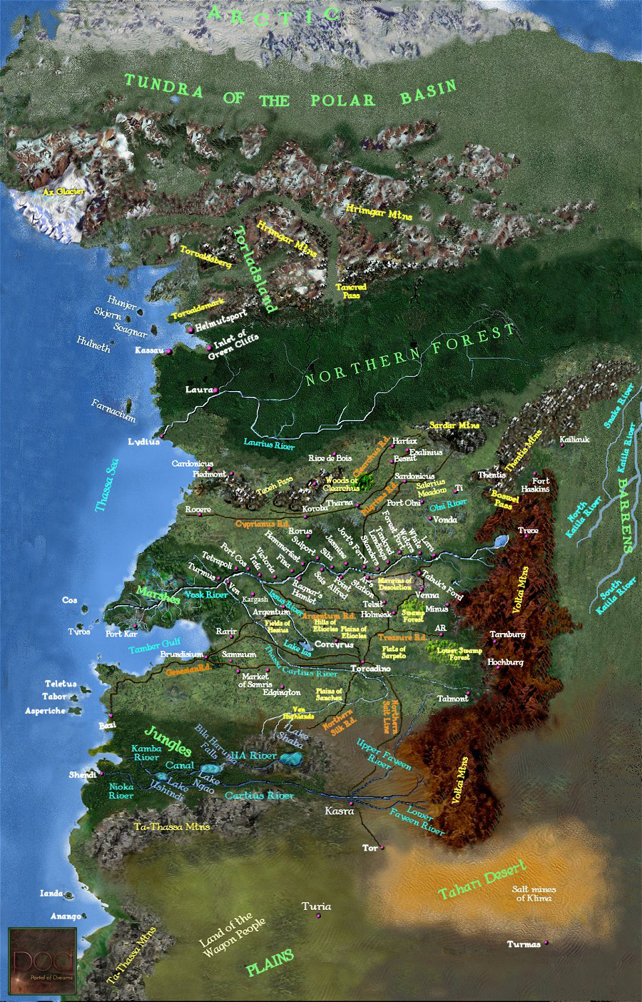
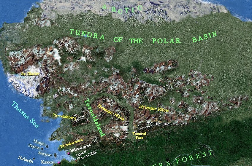
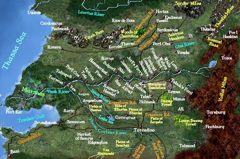
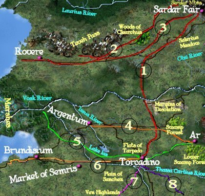
  1. Pilgrim's road: Links Torcadino and the Sardar Fair
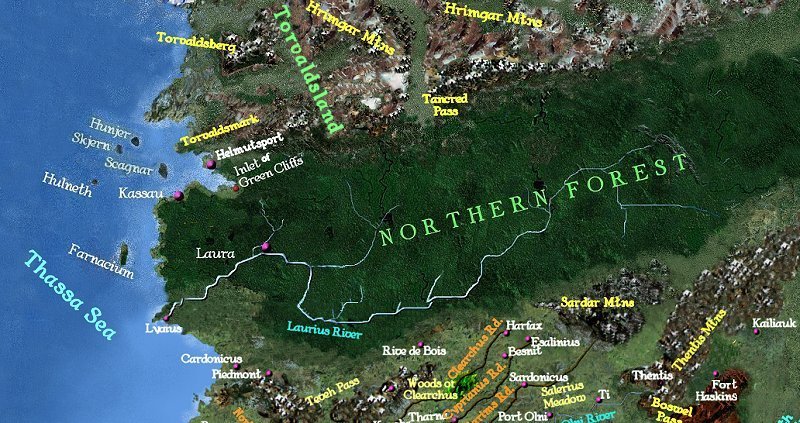
  2. Road of Clearchus, a.k.a. Old West Road: This secondary road once used by military forces links the west to the Sardar
  3. Road of Cyprianus, a.k.a. New West Road: Another secondary road linking the west to the Sardar, Cyprianus is safer and easier than Clearchus and was built to reduce the traffic on the latter
  4. Argentum Road: One of the few that does not pass through Torcadino, this road links Argentum to Ar
  5. Treasure Road, a.k.a. Eastern Road: Links the Western Cities to Ar via Torcadino and constitutes the quickest and most civilized route between Torcadino and Ar
  6. Genesian Road: Links Torcadino and Brundisium
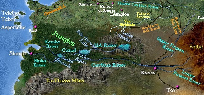
  7. Northern Silk Road: Links Torcadino and the tropics
  8. Northern Salt Line: Links Torcadino and Kasra, as well as the trade routes of the Southern Plains and Tahari desert regions
  9. Vitkel Aria, a.k.a. Vosk Road: Meaning Ar's Triumph, this great road is comparable to the Appian Way of ancient Rome and runs from Ar to the Vosk River.
Supporting Quotes:
"Torcodino, on the flats of Serpeto, is a crossroads city. It is located at the intersection of various routes, the Genesian, connecting Brundisium and other coastal cities with the south, the Northern Salt Line and the Northern Silk Road, leading respectively west and north from the east and south, the Pilgrim's Road, leading to the Sardar, and the Eastern way, sometimes called the Treasure Road, which links the western cities with Ar,"
-- Mercenaries of Gor, pg 101
"Some two years ago the merchants and builders had opened the road of Cyprianus, named for the engineer in charge of the project, which led to the fairs rather from the southwest. This had considerably reduced the traffic on the road of Clearchus, now to its north, which had approached the fairs in such a way as to favor the traffic from the northwest, with the result that several of the establishments on the road of Clearchus had been abandoned or relocated. One advantage of the more southern route is that it passes through less rough terrain, terrain which provides less cover for highwaymen. In particular, it does not pass, for several pasangs, though the woods of Clearchus [which]… incidentally, to this day, remain a haunt of brigands,"
-- Players of Gor, pg 99-100
"The wagon would proceed east on the Argentum road, reach the Viktel Aria, and turn south. Then, in time, it would arrive in Ar,"
-- Kajira of Gor, pg 263
"It also commands, in effect, the northern terminus of one of the great roads, the Viktel Aria, or Ar's Triumph, leading toward Ar. This is also the road popularly known as the Vosk Road, particularly by those viewing it from a riverward direction,"
-- Rogue of Gor, pg 63
"I considered the Barrens. They are not, truly, as barren as the name would suggest. They are barren only in contrast, say, with the northern forests or the lush land in river valleys, or the peasant fields or meadows of the southern rain belts. They are, in fact, substantially, vast tracts of rolling grasslands, lying east of the Thentis mountains…To be sure, the expression 'Barrens' is not altogether a misnomer. They would be, on the whole, much less arable than much of the other land of known Gor. Their climate is significantly influenced by the Thentis mountains and the absence of large bodies of water. Prevailing winds in the northern hemisphere of Gor are from the north and west. Accordingly a significant percentage of moisture-laden air borne by westerly winds is forced by the Thentis mountains to cooler, less-heated air strata, where it precipitates, substantially on the eastern slopes of the mountains and the fringes of the Barrens. Similarly the absence of large bodies of water in the Barrens reduces rainfall which might be connected with large-scale evaporation and subsequent precipitation of this moisture over land areas, the moisture being carried inland on what are, in effect, sea breezes, flowing into low-pressure areas caused by the warmer land surfaces, a given amount of radiant energy raising the temperature of soil or rock significantly more than it would raise the temperature of an equivalent extent of water. The absence of large bodies of water adjacent to or within the Barrens also has another significant effect on their climate. It precludes the Barrens from experiencing the moderating effects of such bodies of water on atmospheric temperatures. Areas in the vicinity of large bodies of water, because of the differential heating ratios of land and water, usually have warmer winters and cooler summers than areas which are not so situated. The Barrens, accordingly, tend to be afflicted with great extremes of temperature, often experiencing bitterly cold winters and long, hot, dry summers,"
-- Savages of Gor, pg 64-65
"Tell me what you know of the Cartius," he said. "It is an important subequatorial waterway," I said. "It flows west by northwest, entering the rain forests and emptying into Lake Ushindi, which lake is drained by the Kamba and the Nyoka rivers. The Kamba flows directly into Thassa. The Nyoka flows into Schendi, and moves thence to Thassa." "It was, at one time," conjectured Samos, "that the Cartius proper was a tributary of the Vosk." "I had been taught that," I said. "We now know that the Thassa Cartius and the subequatorial Cartius are not the same river." "It had been thought, and shown on many maps," I said, "that the subequatorial Cartius not only flowed into Lake Ushindi, but emerged northward, traversing the sloping western flatlands to join the Vosk at Turmus." Turmus was the last major river port on the Vosk before the almost impassable marshes of the delta.
"Calculations performed by the black geographer, Ramani, of the island of Anango, suggested that given the elevations involved the two rivers could not be the same. His pupil, Shaba, was the first civilized man to circumnavigate Lake Ushindi. He discovered that the Cartius, as was known, enters Lake Ushindi, but that only two rivers flow out of Ushindi, the Kamba and Nyoka. The actual source of the tributary to the Vosk, now called the Thassa Cartius, as you know, was found five years later by the explorer, Ramus of Tabor, who, with a small expedition, over a period of nine months, fought and bartered his way through the river tribes, beyond the six cataracts, to the Ven highlands. The Thassa Cartius, with its own tributaries, drains the highlands and the descending plains,"
-- Explorers of Gor, pg 16-18
Even in the reduced scale of the map the desert seemed vast. Its mere representation, as earlier indicated, covered several square feet of the floor. It was roughly in the shape of a gigantic, lengthy trapezoid, with eastward leaning sides. At its northwestern corner lay Tor. West of Tor, on the Lower Fayeen, a sluggish, meandering tributary, like the Upper Fayeen, to the Cartius, lay the river port of Kasra, known for its export of salt.
-- Tribesmen of Gor, pg 33
The Wagon Peoples claimed the southern prairies of Gor, from gleaming Thassa and the mountains of Ta-Thassa to the southern foothills of the Voltai Range itself, that reared in the crust of Gor like the backbone of a planet. On the north they claimed lands even to the rush-grown banks of the Cartius*, a broad, swift flowing tributary feeding into the incomparable Vosk. The land between the Cartius and the Vosk had once been within the borders of the claimed empire of Ar, but not even Marlenus, Ubar of Ubars, when master of luxurious, glorious Ar, had flown his tarnsmen south of the Cartius.
-- Nomads of Gor, pg 2
* Later identified as the Thassa Cartius, rather than the subequatorial Cartius that was once mistakenly believed to flow into Lake Ushindi and then emerge northward to flow to the Vosk.